Well Report Query User Guide
Overview
Oregon Water Resources Department maintains Well Report records for the State of Oregon.
Public access to these records are being provided free of charge. Please be sure to read and understand the
following disclaimer concerning the use of this information.
Disclaimer
The information provided in the tabular information is a subset of information captured from the
original well report submitted by the well constructor. Though the Department takes great care to ensure
that the data entered is correct, there are data entry errors. The reproduction of the submitted
well report in image format is available and takes precedence over the tabular data.
The Department cannot, and does not, accept any responsibility for errors, omissions, or accuracy of information
in the Well Report database. There are no warranties, expressed or implied, including the warranty of merchantability or
fitness for a particular purpose, accompanying this information. However, notification of any errors would be appreciated.
To search for well reports, enter the information about the area or well reports for which you want to
search. Information that has been entered or selected are combined together to make a query. Information
that is left blank is not included in the selection criteria. Once you have specified the criteria, click on the Search button. If you want to erase
the criteria you have entered and start fresh, click on the Reset button. The following sections
describe each of the options on which you can search:
Search by Township, Range, and Section
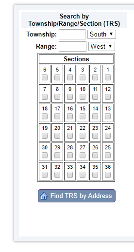
Township and Range lines were defined by Public Land Surveyors in the late 1800's. They define a grid
for Oregon and Washington from which all other land surveys are ultimately based. Townships run North and
South and Ranges run East and West. In Oregon Township numbers span from 9 North to 41 South and
Range numbers span from 50 East to 16 West. While slightly confusing, the combination of a
Township number and a Range number uniquely identify a square called a Township.
Each Township is further divided into a grid of 36, one square mile sections . Click on the check box beneath each of
the sections you wish to display.
Find TRS by Address
If you don't know what Township/Range/Section of the location you are looking for,
you can attempt to locate it via the "Find TRS by Address" button. You will be
provided a box that will allow you to enter the address of the location. Enter
it in a format similar to "725 Summer ST NE Salem, OR". This address lookup uses
a free geocoding service based on government TIGER data. Note: You may not be able to
find all addresses using this tool. Once you have the TRS, then move over to the “Search Well Report Information” on the right side of the webpage.
This is where you search our database using information from the well reports. More current well reports filed through e-filing are more complete. Older well reports may only have partial information
entered into the database. Likewise, older well reports had less requirements and may not be as detailed as current well reports. If you found a well label on the well, only enter that number. If you don’t have a label or specific information from the well report, then you should skip down to “Type of Report”, below.
Well Log:
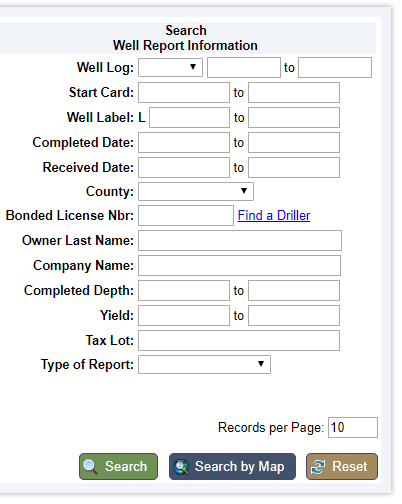
Once a well report has been submitted, the Department assigns a Well Report identifier for the database. This identification is the combination of a county code (which may be different than the county where the well is located) and a numeric id. The combination of these fields allows you to locate an individual well report via this reference number, often refered to as a Well Log.
A range of numbers may also be searched, though all for the same county.
Start Card:
Well constructors file a notice of intent to construct a well called a start card. These are given
a unique number. This field allows you to locate an individual well report via this reference number.
A range of numbers may also be searched.
Well Label:
After June 1996, wells constructed, or altered, or on property that has changed ownership, should have a metal label placed on
them with this number. This field allows you to locate an individual well reports via this reference number. A range of numbers may also be searched.
Completed Date Range:
This field allows you to specify the date range for which you are searching. Enter the dates in a
MM/DD/YYYY format.
Received Date Range:
This field allows you to specify the date range for which you are searching. Enter the dates in a
MM/DD/YYYY format.
County:
If you don't know the Township or if you want to limit the specified Township to a certain county, you
can use the County selection. This will enable you to choose 1 of the 36 counties in Oregon. You can specify
to ignore the county selection by choosing the blank county option. For example, you can combine owner name
and County to locate wells when you don't know the township information.
Bonded License Nbr:
This is the bonded license number of the well constructor. If only a name is known, use the "Find a Driller" link to
search for the well constructor.
Owner Last Name:
The owner name is typically the person who had the well constructed. Usually, this is
the landowner at the time the well was constructed. Enter the last name of the person for which you wish
to search. The search will automatically return all names that contain the text you enter. For example if
you enter "MAC" the system will bring back records such as "MACDONALD", "MACINTOSH", and "DORMACK".
Company Name:
The company name is typically the name of the company who had the well constructed. However, it is also
used to store the names of secondary owners. For example if a well report stated that the owner was Mr. and Mrs. John Doe, the
owner name would be Mr. John Doe and the Company name would be Doe, Mrs. John. To search on this field, enter the name of the "company"
for which you wish to search. The search will automatically return all names that contain the text you enter. For example if
you enter "MAC" the system will bring back records such as "MACDONALD", "MACINTOSH", and "DORMACK".
Completed Depth Range:
The Completed Depth is the finished depth of a well. This field allows you to specify the range of depths
for which you are searching.
Yield Range:
Some wells have had a yield test done. A yield test consists of
determining the balance between the maximum amount of water that can be pumped and the amount
of recharge back into the well from the surrounding groundwater. Testing is done by continuously pumping water from the
well for an extended period, usually an hour or more. This field allows you to specify the range of yields
for which you are searching.
Tax lot:
To search by this identifier, enter it in the tax lot field. Keep in mind that the tax lot may have changed since the report was filed, or it may not be listed on the report at all.
Type of Report:
Select one of the options of the type of report to limit the search, as needed. Choose "Water Well", unless you are looking for a monitoring well or geotechnical hole.
Records per Page:
Searches may return hundreds of records. To get the most scrollable results without overwhelming your browser, add a “0” to “10” so that up to 100 records will come up on the result page.

The search by map is a hyperlink to the Well Report Mapping Tool. This tool provides an interactive map for searching well locations using many of the well report attributes listed above. It is limited to 1000 records. Please Note: Not all wells have exact GPS locations, so it may be best to stick with the database search, especially for older wells. The Well Report Mapping Tool has its own help file.
Back to Top
|