Understanding the Well Report Search Results
Once you have successfully performed a search, you will be presented with a screen full of information.
The following section answers some of the questions you may have about this screen.
How do I view the well report image?
The well report images are provided as Adobe Acrobat (PDF) files. You will need to have the current version
of Adobe Acrobat installed to view them. You can download the free viewer at: www.acrobat.com
What do these columns of data mean?
There is a wealth of information provided when you retrieve well report records. The section below defines
or describes these columns.
This field is a unique key for a given well report. The combination of County Code and Well Number ID# is created
when a well report is entered into the GRID system. You may see some records where the Well Report ID is list multiple times
with version numbers. There are some well reports where through field inspection, Department
Staff, or other sources, we have discovered that the data on the original well report is not accurate. On those logs,
we add another record with a higher version.
This column is also used as a place where you can display the well report image. Simply click on the Well Log ID
and you will be able to view the well report image.
All of the information regarding the well report that has been entered into the well report database is displayed
in a consistent format with a locational map.
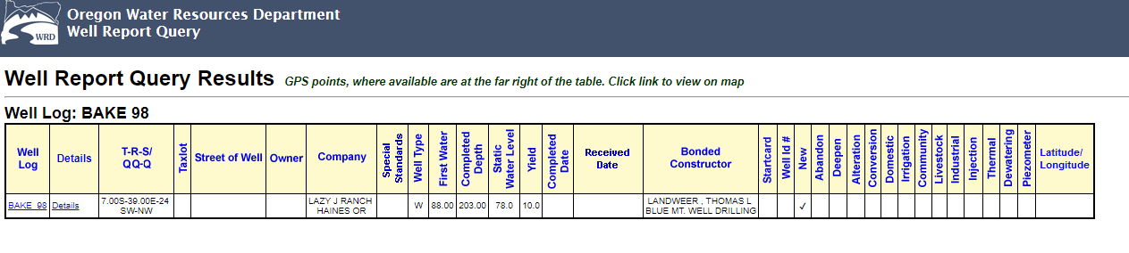
This column provides the locational information for a well. The abbreviation T-R-S/Q-QQ stands for
Township - Range - Section / Quarter Quarter
Township and Range lines were defined by Public Land Surveyors in the late 1800's. They define a grid
for Oregon and Washington from which all other land surveys are ultimately based. Townships run North to
South and Ranges run East to West. In Oregon Township numbers span from 41 South to 9 North and
Range numbers span from 16 West to 50 East. While slightly confusing, the combination of a
Township number and a Range number uniquely identify a square called a Township.
The surveyors where not perfect in laying out this grid, which resulted in gaps in the
grid. Once these gaps were located, they were labeled as fractional townships such as 33 and 1/2
Each Township is divided into a grid of 36 sections. Each section is further divided into
four equal parts (about 160 acres each) called Quarters. Each 160 acre Quarter is then divided again
into four 40 acre parts called a Quarter-Quarter.
This column displays the tax lot that was recorded on the well report at the time of
construction. Since this information changes over time, this may or may not be the current tax lot for
the property. Tax lot numbers have been required on well reports since 1996.
The address of the property where the well was constructed. This information may or may not be the
current address of the property due to address changes.
The owner name is typically the person who had the well constructed. Usually, this is
the landowner at the time the well was constructed.
Company Name
The company name is typically the name of the company who had the well constructed. However, it is also
used to store the names of secondary owners. For example if a well report stated that the owner was Mr. and Mrs. John Doe, the
owner name would be Mr. John Doe and the Company name would be Mrs. John Doe.
The type of well constructed. These include:
- W - Water Supply
- M - Monitoring
- G - Geotechnical Hole
First Water
Depth indicated by the constructor of when water was first encountered.
Completed Depth
Depth of the finished well. This can be different than the actual depth drilled.
Static Water Level
The level that water came to rest in the well after the construction was completed.
Yield
After the well is constructed, a test is performed to estimate the amount of water the well is
able to produce. This columns lists the maximum value from these tests entered on the well report.
Date the well was finished.
Name of the constructor who is legally responsible for construction of the well.
Well constructors file a notice of intent to construct a well called a start card. These are given
a unique number. These notices are confidential from one year of filling or until the well report is received by the
Department.
Beginning in June 1996, wells are tagged with a numbered, metal tag. This is the Well Label.
These columns denote the type of work being performed. These activities include new construction,
abandonment, deepening, reconditioning, and repair.
Well Uses
Wells are used for numerous purposes. These fields denote the different types of uses a well might have.
The use indicated on the log is the original use the owner indicated. This may have changed over time.
- Domestic Use
- Irrigation
- Community
- Industrial
- Injection
- Thermal
- Livestock